A morning glory is a flower, right?
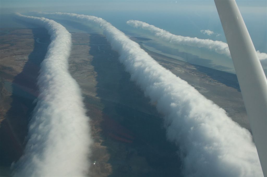
Yes, and it’s also the name of these very rare roll clouds that stretch as much as 1000 km. That’s 620 miles, the distance from Pittsburgh to Dallas, Texas!
I’ve never seen a morning glory cloud but the literature says they are low and tubular and appear to be rolling on their horizontal axis. They travel up to 60 kilometers per hour (37 mph) over a landscape that has no wind at ground level — until they arrive.
Morning glories bring wind with them and such great updrafts on the leading edge that glider pilots flock to the only place on earth where these clouds reliably occur: northern Australia’s Gulf of Carpentaria from August to November. Some have ridden these clouds for 500 km (310 mi).
Morning glory clouds can form (rarely) in response to severe thunderstorms but in Queensland they’re caused by sea breezes that flow onshore overnight at the Cape York Peninsula. The moist air comes from both east and west, meets in the middle over the peninsula, and rises into a stack of cold, turbulent air. Before dawn the stack is blown westward over the Gulf and causes ripples in the sky, each one carrying a long roll cloud.
Right now it’s spring in Australia and prime season for this rare phenomenon. In Burketown, Queensland the glider pilots awake before dawn, hoping for glory.
(photo by Mick Petroff via Wikimedia Commons. Click on the image to see the original)
How cool is this? Never saw one. Thanks