Category Archives: Weather & Sky

Action Maps of Wind, Waves and More

Screenshot of ocean currents from earth website

26 January 2023

More fun with maps!

Earlier this month when I wrote about wind speed maps (How Fast Is The Wind Blowing?) Steve Thomas sent a link to the earth mapping website. I remembered green swirling maps on my own blog, Winds On Water, but seven years ago I didn’t look further than the default surface winds.

The earth website is, in their own words, “a visualization of global weather conditions forecast by supercomputers updated every three hours.” Their action maps include high altitude winds, ocean currents, temperatures, fires and more.

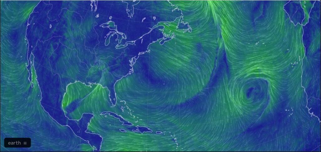
Let’s start exploring with today’s map of surface winds, shown below (click here to open it on your own computer). I guarantee it will look different than this image I pulled yesterday.

Surface winds over the continental U.S. and mid latitudes of North Atlantic, 25 January 2023 (screenshot form earth)

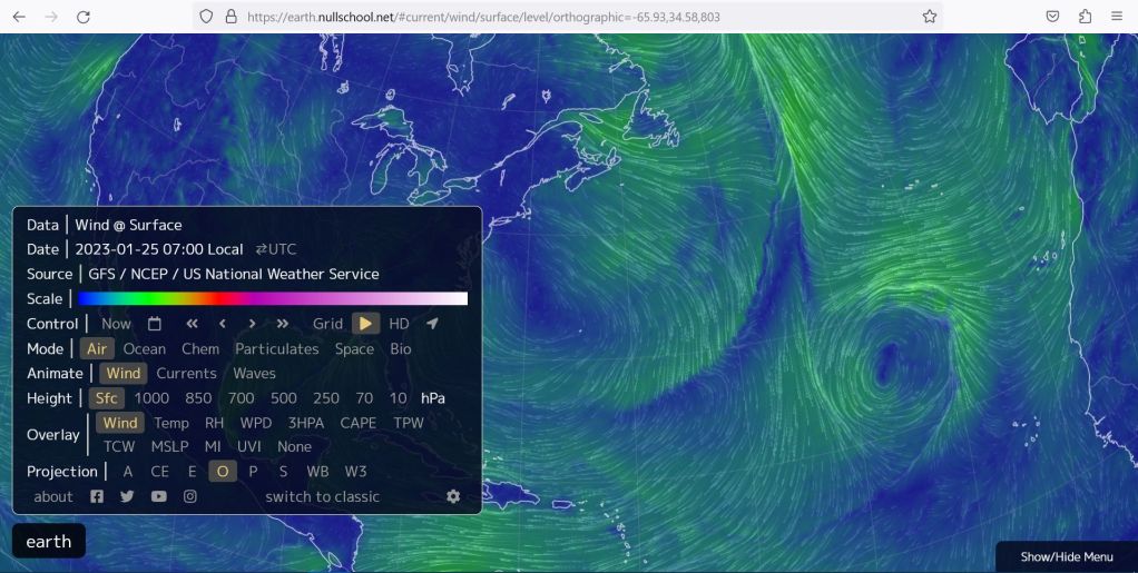
To see the legend and change the map click on the [earth] icon at bottom left. The default setting is:

  • Mode=Air
  • Animate=Wind
  • Height=Sfc (surface)
  • Overlay=Wind
Screenshot of legend at earth website

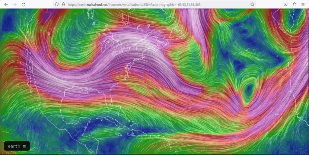
To see winds at higher altitude I chose Height=250. [250 hPa = 250 hectopascals = lower pressure = higher altitude. The lower the hPa number, the higher the altitude above the surface.]

  • Mode=Air
  • Animate=Wind
  • Height=250
  • Overlay=Wind

The wind is screaming purple-white at 250 hPa. It looks like the jet stream.

Screenshot of winds at height 250hPa from earth website

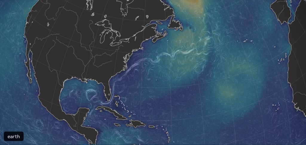
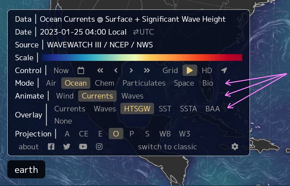
To achieve the map of ocean currents shown at top I chose:

  • Mode=Ocean
  • Animate=Currents
  • Overlay=HTSGW (Significant Wave Height)
Screenshot of legend at earth website

Click here to see an action map of the Gulf Stream at the ocean’s surface (screenshot at top). Watch it rounding the tip of Florida, then pumping north and east into the Atlantic, leaving vortices in the Gulf of Mexico.

That strong current near the east coast of Florida is the water “highway” that many creatures use for migrating north. It’s the reason why you can see whales from shore in early spring.

Try out the other options on earth to have more fun with maps.

(all maps are screenshots from earth, base maps for these screenshots can be found at this link https://earth.nullschool.net/#current/wind/surface/level/orthographic=-65.93,34.58,803)

See The Green Comet … If You Can

Comet C/2022 E3 (ZTF) imaged using 300mm F/4 lens, 21 Jan 2023 (photo by Auvo Korpi via Wikimedia Commons)

23 January 2023

A green comet that last passed the sun 50,000 years ago set off a flurry of stargazing on the night of the new moon, 21-22 January. Even though Comet C/2022 E3 (ZTF) will pass closest to earth on 2 February it is best to see it now before the moon waxes to full on 5 February.

video from @MrSuperMole on YouTube

Comet C/2022 E3 (ZTF) is so faint that it must be viewed in a dark sky and is best seen via binoculars, telescope, or camera with telephoto lens — for instance, birding equipment. The photo above was taken with a 300mm F/4 lens. Click here for information on where to look.

With magnification and a star map all you need is a dark sky, but finding one is increasingly difficult.

A study published last week in the journal Science examined 12 years of citizen science reports of the constellations seen with the naked eye. The number of constellations seen from 2011-2022 went down as sky glow increased from lights on earth. As Smithsonian Magazine explains, the brightness of light pollution increased at a rate of 9.6 % per year. “That’s equivalent to the brightness doubling every eight years.”

Previous studies used satellites to measure earth lights reaching outer space but they missed the effect of ground lights inside our atmosphere. So the problem is worse than we thought. For a video illustration, see the 2016 article below.

Meanwhile in Pittsburgh, we definitely have light pollution but our impossible hurdle is cloud cover. We have lots of clouds in the forecast for the next 10 days.

Pittsburgh 10-day forecast from weather.com app on cellphone (screenshot from Kate St. John)

Read more about the light pollution study in Smithsonian Magazine: Light pollution is drowning the starry night sky faster than thought.

(photo from Wikimedia Commons, video from @MrSuperMole on YouTube, screenshot from weather.com on cellphone)

How Fast Is The Wind Blowing?

Oak leaf on an updraft in winter (photo by Marcy Cunkelman)

17 January 2023

We can’t see the wind but we can guess its speed by watching what it does to leaves and flags …

Wales national flag blowing in the wind (photo from Wikimedia Commons)

… and then using the wind speed chart from the National Weather Service (NWS) to make a guess. My guess for the above photos is a Gentle Breeze 8-12 mph or a Moderate Breeze 13-18 mph but it’s hard to tell.

Estimating Wind Speed (chart from the National Weather Service)

NOAA weather satellites don’t see the wind either but they can see the clouds moving in three layers.

  • High level clouds (cirrus) at 23,000 to 46,000 feet
  • Mid level clouds at a level of 10,000 to 23,000 feet
  • Low level clouds are below 10,000 feet

In their animations of satellite images we can almost see the wind but not its speed.

For instance, in this GOES East animation from last Thursday 12 January 2023 we can see the Atmospheric River pumping into California and a low pressure system moving up the Ohio Valley.

GOES EAST satellite, GeoColor timelapse images, 12 Jan 2023 6:56Z-10:51Z (animation from NOAA)

NOAA’s computers use the animated maps to calculate wind speed and direction. The result, called Derived Motion Winds, plots the wind height, direction and speed on a map.

Legend for Derived Motion Winds: Wind Height and Speed (NWS)

Here’s the same timelapse with Derived Motion Winds. Notice that the layers often don’t move in the same direction or at the same speed. You’ve felt this in an airplane as a “bump” when the plane rises or descends between conflicting layers.

GOES EAST CONUS, Derived Motion Winds 12 Jan 2023 (animation from NOAA)

You can “see” the wind anywhere in the Americas by choosing a satellite to view (list on the left) at the NOAA GOES Imagery Satellite Maps. Click on Derived Motion Winds if available.

To view the current GOES East satellite, pictured above, visit these links:

(photos from Marcy Cunkelman and Wikimedia, maps and animations from NOAA and the National Weather Service)

Lake Effect Clouds and the Classic Gleam at Sunset

The Gleam At Sunset, 14 Jan 2023 (photo by Kate St. John)

16 January 2023

Pittsburgh’s skies were oppressively gray on Saturday with thick Lake Effect Clouds but the forecast promised the clouds would break in early afternoon so I planned a walk in Schenley Park for 2:30pm. Hah!

By 3pm the clouds were still thick and gray and the revised forecast predicted they would break up in the 4 o’clock hour. Of course! We were about to get 15-30 minutes of full sun immediately followed by sunset at 5:15pm, a classic Gleam At Sunset. I timed my walk to arrive at Schenley’s golf course by 4:45pm.

My photos show what happened: the classic gleam, an unexpected sun pillar, and a beautiful red sky at sunset.

If you’ve never heard of Lake Effect Clouds and the Gleam At Sunset, find out more in last month’s article:

(photos by Kate St. John)

Seen This Week

Sunrise, 11 Jan 2023 (photo by Kate St. John)

14 January 2023

The sunrise was gorgeous and cold last Wednesday when a group of us decided to walk at Jennings in Butler County. We saw few birds but there were ice heaves, buttress roots on an elm, and the seeds of old man’s beard (Clematis drummondii).

Ice heave at Jennings, Butler County 11 Jan 2023 (photo by Kate St. John)
Elm tree with buttress roots, Jennings, Butler County, 11 Jan 2023 (photo by Kate St. John)

When old man’s beard is in bloom it’s called virgin’s bower, transforming it from a young woman to an old man in a matter of months.

Seeds of Virgin’s bower, a.k.a. Old man’s beard, Jennings, Butler County, 11 Jan 2023 (photo by Kate St. John)

My friends who live north of the city have not seen many dark-eyed juncos at their feeders this winter, but juncos are definitely present at the Frick Park Environmental Education Center. Charity Kheshgi posted photos of our recent trip to Frick.

(bird photos by Charity Kheshgi embedded from Instagram, all other photos by Kate St. John)

Was The Snow Really Deeper When I Was A Kid?

Snow on sweet gum seed balls, Pittsburgh, 17 December 2020 (photo by Kate St. John)

4 January 2023

Rain. Rain. Rain! For two days it’s been raining in Pittsburgh while the high temperature holds at 61oF. Total rainfall will be 1.4 inches, some of which splashed the Cathedral of Learning falconcam.

Rain distorts the Cathedral of Learning falconcam, 3 January 2023

If the weather had been below freezing we’d be looking at 14 inches of snow! I’m glad it isn’t snowing but heavy rain in January got me thinking … Wasn’t the snow deeper when I was a kid?

I grew up in Pittsburgh so my memories of winter apply to where I live today, but are my memories distorted? Using Pittsburgh’s historical snowfall data I compared my 12 years of growing up in Pittsburgh(*) to the most recent 12 years.

The answer is mixed. There was more snow in winter when I was a kid (maximum winter total and highest minimum), but both the highest and lowest snowfall per month both occurred in the recent past — in fact in the same winter of 2020-21.

DescriptionWhen I Was a KidInchesInchesThe Last 12 Winters
Max Winter TotalWinter 1960-6176.063.4Winter 2013-14
Min Winter TotalWinter 1968-6930.422.4Winter 2019-20
Max Monthly TotalJan 196624.627.5Jan 2021
Min Monthly TotalMar 19611.40.1Mar 2021 (same yr as max)
Snow in May?Up to 3.1 inchesNo snow sticks in May

The wild swings in snowfall nowadays mirror the wild swings in temperature.

Remember how bitter cold it was only 11 days ago? Look at the temperature swing then (Christmas Eve 2022) and now (3 January 2023)!

So the answer is Yes & No. Yes, there was more snow in Pittsburgh when I was a kid. But, No, the snow is deeper today on rare occasions.

Curious about snowfall in Pittsburgh? Check out the historical data at NWS Pittsburgh and the Rain to Snow Calculator here.

(*) The span is 12 years because I moved to Pittsburgh when I was 6 years old.

(photo by Kate St. John, maps and data from the National Weather Service)

Wrapping Up 2022: Seen In 2 Weeks

Pastel sunrise on 14 December 2022 (photo by Kate St. John)

31 December 2022

The end of the year was a weather yo-yo from warm-ish winter to bone chilling cold to 60 degrees yesterday. Photos from the last two weeks span Pittsburgh and Virginia.

Above, a pastel sunrise on 14 December in Pittsburgh was followed by above freezing weather. It was so warm that by the 17th I found a bench gnome in Schenley Park and blooming trees at Carnegie Museum.

Whimisical gnome beneath a stone bench in Schenley Park, 17 December 2022 (photo by Kate St. John)
Flowering cherry in bloom at Carnegie Museum, 17 December 2022 (photo by Kate St. John)

That evening it dipped below freezing and stayed cold through sunrise on the 21st. The blossoms did not survive.

Frosty sunrise on 21 December 2022 (photo by Kate St. John)

And then it got Nasty cold.

To avoid the coming winter storm we drove to Virginia on Wednesday the 21st. On Thursday in Virginia it poured, on Friday it turned sharply cold.

Finally on Saturday in Virginia Beach the temperature reached the mid 20s in the afternoon so I took a walk and found a young male common yellowthroat with bright yellow throat, olive back and shadow mask (sample photo at left). A warbler(!) had survived the coldest night of 13 degrees F and was gleaning dead insects from the sunlit grass. He was on the path in the photo at right, but of course we cannot see him.

There was a common yellowthroat warbler here in the grass! Lynnhaven Park, Virginia Beach, 24 December 2022 (photo by Kate St. John)

On 26 December when I visited Back Bay NWR there were thousands of waterfowl including tundra swans, gadwall, wigeons, black ducks, ring-necked ducks, scaup, ruddy ducks, and coots (see checklist here).

The freezing weather had created odd ice formations above the water.

Ice on the reeds at Back Bay NWR, 26 December 2022 (photo by Kate St. John)
A closer look at ice on the reeds at Back Bay NWR, 26 December 2022 (photo by Kate St. John)

At sunset in Smithfield, VA on 27 December it was comfortably above freezing. I put away my parka.

Sunset in Smithfield, Virginia, 27 December 2022 (photo by Kate St. John)

No coat necessary while we drove home on 28 December. And there was a beautiful sunset in western PA.

Sunset along the PA Turnpike, New Stanton Rest Stop, 28 December 2022 (photo by Kate St. John)

The week ahead promises warm temperatures with rain all day for the Christmas Bird Count. Erf! Will I find the crows?

(common yellowthroat photo from Wikimedia Commons, all other photos by Kate St. John)

Winter Solstice

Winter sunrise in Leicestershire (photo by ItsNoGame via Flickr Creative Commons license)

21 December 2022

Today at 4:47pm ET the sun will pause in its southward journey down the sky and begin moving north.

This year’s solstice occurs near sunset: 9 minutes after sunset in Philadelphia (4:38pm ET), 9 minutes before sunset in Pittsburgh (4:56pm ET). If you live in Shippensburg, PA sunset and the winter solstice will happen simultaneously.

Soon the days will be longer and birds will begin to sing. Here’s what we can look forward to on a warm day in late January.

(photo by ItsNoGame via Flickr Creative Commons license; click on the caption to see the original)

Why Do We Have a Gleam at Sunset?

The Gleam at Sunset, Pittsburgh, 2 Feb 2021 (photo by Kate St. John)

18 December 2022

Often in winter Pittsburgh has overcast skies all day and clear skies at night. When the transition happens at sunset we see clear sky approaching from the west but it arrives too late for us to enjoy the sun. We have 10 minutes of sunshine and then it’s dark. I call this The Gleam At Sunset.

Why does this happen so often? Does Ohio have lovely weather all day that only reaches us at night?

Gleam at sunset, Downtown Pittsburgh in the distance, 2016 (photo by Kate St. John)

Myranda Fullerton at the National Weather Service in Pittsburgh told me why. Her answers are paraphrased below.

Lake Effect Clouds

Pittsburgh is well known for overcast skies in winter but you may be surprised where the clouds come from.

Lake Erie plays an extensive role in our cloud cover and, as long as it isn’t frozen over during the winter, it serves as a local moisture source that plagues the region with clouds. … Most places have clear blue skies after a cold front passage, but when we have northerly flow off of the lake we have cloud cover.”

Myranda Fullerton, NWS Pittsburgh, email paraphrased

Buffalo, New York has Lake Effect Snow. I like to think that Pittsburgh has “Lake Effect Clouds.”

Mixing and the Boundary Layer

When the air is well mixed (wind and/or rising warm air, falling cold air) it creates a defined line between the clouds and the rest of us below. In winter and early spring this mixing happens while the air is heated during the day.

During the winter and early spring, often times we observe a well-mixed boundary layer (we call this boundary layer coupling). When the atmosphere is coupled/mixed, the top of that mixing height is where we observe a cloud base [i.e. the bottom of the overcast deck].  You may even feel gusty wind during the day that supports the notion of a mixed atmosphere, when strong wind aloft is transported to the surface through this means. 

Myranda Fullerton, NWS Pittsburgh, email paraphrased

Stable Air is Clear

The cloud base remains well defined while the air is mixing. It falls apart when the mixing stops at sunset.

At night, wind gusts typically subside as the surface cools and the atmosphere becomes decoupled again in tandem with sunset / loss of daytime heating. At decoupling you may lose your mixing height and essentially dissolve your cloud cover.

Myranda Fullerton, NWS Pittsburgh, email paraphrased

So Pittsburgh’s typical winter is: Overcast clouds during the day. Clouds breaking up at sunset for a Gleam at Sunset. Then clear skies at night.

Still puzzled by the boundary layer? Click here for a video that explains it.

(photos by Kate St. John)

Variable Cloudiness

Rising moon reflected in the Monongahela River at Duck Hollow, 5 Dec 2022, 4:23pm (photo by Kate St. John)

10 December 2022

In December daylight is in short supply and the skies are often gray so clouds have a big effect on our mood in Pittsburgh. This week ranged from brilliantly sunny to thick overcast, from exhilarating to subdued (depressed?) depending on the variable clouds.

Above, on the miraculously clear afternoon of 5 December the moon rose over still water at Duck Hollow. Below, a line of clouds at sunrise painted the sky red on 2 December.

Sunrise in Pittsburgh, 2 Dec 2022, 7:16am (photo by Kate St. John)

The next day I was scouting for crows on Mt. Washington when crepuscular rays peeked through the clouds at sunset. Do you see the crows? They’re tiny black dots in the sky.

Crepuscular rays at sunset with crows in flight to Mt Washington’s “Saddle,” 3 Dec 2022, 4:42pm (photo by Kate St. John)

The clouds were so low on 6 December that fog engulfed the top of the Cathedral of Learning. Morela came down to Heinz Chapel’s scaffolding to look for birds in the nearby trees. Do you see her in the middle of the photo?

Peregrine on Heinz Chapel scaffolding, 6 Dec 2022, 12:39pm (photo by Kate St. John)

Last night’s clouds partially obscured the waning moon while moonlight made a colorful halo.

Moon halo, 9 Dec 2022, 7:57pm (photo by Kate St. John)

Today we’re back to overcast skies with 85% to 96% cloud cover for the next two days. Alas. No variation until Tuesday.

(photos by Kate St. John)